NOAA Great Lakes Environmental Research Laboratory

The latest news and information about NOAA research in and around the Great Lakes


Leave a comment

The HAB season is over, but the work goes on

It’s nearly winter here in the Great Lakes—our buoys are in the warehouse, our boats are making their way onto dry land, and folks in the lab are working hard to assess observed data, experiments, and other results from this field season.

habtracker2018

This is a retrospective animation showing the predicted surface chlorophyll concentrations estimated by the Experimental Lake Erie HAB Tracker model during the 2018 season. Surface chlorophyll concentrations are an indicator of the likely presence of HABs. For more information about how the HAB Tracker forecast model is produced and can be interpreted, visit our About the HAB Tracker webpage.

The harmful algal bloom (HAB) season is also long over in the region. The final Lake Erie HAB Bulletin was sent out on Oct. 11, as the Microcystis had declined in satellite imagery and toxins decreased to low detection limits in samples. In the seasonal assessment, sent out by NOAA’s Centers for Coastal Ocean Science on Oct. 26, it was determined that the season saw a relatively mild bloom—despite its early arrival in the lake—and the bloom’s severity was significantly less than that which was predicted earlier in the season. These bulletins and outlooks are compiled using several models. Over the winter, the teams working on the models take what they learn from the previous season, and update their models for future use.

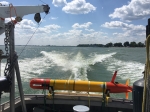
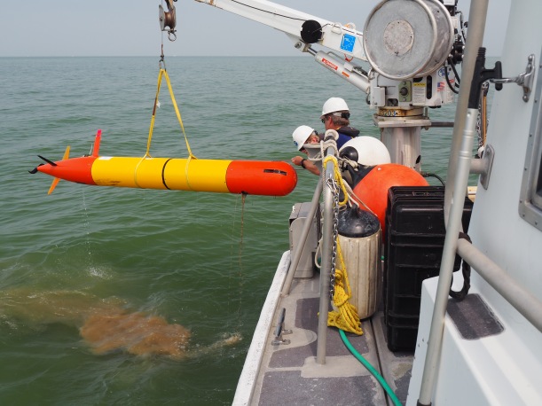
Back in the lab, the HABs team—researchers from both GLERL and the Cooperative Institute for Great Lakes Research (CIGLR)—will spend the winter analyzing data they collected through a variety of observing systems. This summer was packed with the use of new observing technologies, like hyperspectral cameras and the Environmental Sample Processor (in case you missed it, check out this fun photo story of the experimental deployment of a 3rd generation ESP). In addition, GLERL and CIGLR staff maintained a weekly sampling program program, from which scientists are analyzing and archiving samples and conducting experiments.

43447135081_b893240224_o.jpg

Aerial photograph of the harmful algal bloom in Western Basin of Lake Erie on July 2, 2018, (Photo Credit: Aerial Associates Photography, Inc. by Zachary Haslick). Pilots from Aerodata have been flying over Lake Erie this summer to map out the general scope of the algal blooms. In addition to these amazing photos, during the flyovers, additional images are taken by a hyperspectral imager (mounted on the back of the aircraft) to improve our understanding of how to map and detect HABs. The lead researcher for this project is Dr. Andrea VanderWoude, a NOAA contractor and remote sensing specialist with Cherokee Nation Businesses. For more images, check out our album on Flickr.

This lab work is super important for understanding the drivers of toxic algae in the Great Lakes. For instance, in a new study released this month, researchers looking at samples from previous years found that “ . . . the initial buildup of blooms can happen at a much higher rate and over a larger spatial extent than would otherwise be possible, due to the broad presence of viable cells in sediments throughout the lake,” according to the lead author Christine Kitchens, a research technician at CIGLR, who works here in the GLERL lab. This type of new information can be incorporated into the models used to make the annual bloom forecasts.

As you can see, our work doesn’t end when the field season is over.  In spring 2019, when the boats and buoys are back in the water and samples are being drawn from the lakes, researchers will already have a jump on their work, having spent the winter months analyzing previous years, preparing, and applying what they’ve learned to the latest version of the Experimental HAB Tracker, advanced observing technologies, and cutting-edge research on harmful algal blooms in the Great Lakes.


1 Comment

Photo story: Using an AUV to track algae in Lake Erie

In late July and early September, during the peak of the 2018 harmful algal bloom in the Western Basin of Lake Erie, NOAA GLERL, NOAA National Centers for Coastal Ocean Science (NCCOS), NOAA Atlantic Oceanographic and Meteorological Laboratory (AOML) and CIGLR researchers teamed up with a group of scientists and engineers from the Monterey Bay Research Institute (MBARI). Their mission: to test how well a third-generation environmental sample processor (3GESP), mounted inside a long-range autonomous underwater vehicle (LRAUV), can track and analyze toxic algae in the Western Basin of Lake Erie. You can read more about the purpose of this project in this great news story by MBARI’s Kim Fulton-Bennett.

Below is a photo story showing all (well, much) of the hard work that went into this test deployment.

First, the new gear had to be shipped from California to the GLERL laboratory in Ann Arbor, Michigan.


ESP3-b (1)

Upon arrival, Jim Birch, Director of the MBARI SURF (Sensors Underwater Research of the Future) Center, & Bill Ussler, MBARI biogeochemist, got straight to work in GLERL’s Marine Instrumentation Lab.

Image from iOS (6)

The inside of the 3G ESP has a lot of moving parts. Since this is the first time the team is testing it in freshwater, before it can go out, everything needs to be fine-tuned to work in a variety of conditions in Lake Erie (more on that later.)

So. Many. Moving. Parts.


Image from iOS (7)

Once everything is in working order, the 3GESP gets inserted into an LRAUV or long-range autonomous underwater vehicle (the torpedo-looking thing). This gives the 3GESP the ability to move around in the water all by itself once researchers have set parameters for it. The team has named this particular vehicle, Makai, which is Hawaiian for “toward or by the sea.” Seems appropriate! That’s Brian Kieft, MBARI software engineer, on the right. He plays a crucial role in making sure Makai does her job.

IMG-1263

All hands on deck for a few more tweaks.

testing_b

Once everything is installed tightly, helium is added into the canister to check for leaks. CIGLR engineer, Russ Miller, is working with Jim to fill it up.

Now, the team is ready to head out to Lake Erie. Here’s where things start to get exciting!


20180822_134836.jpg

Before the team sets Makai free to track the algal bloom in the Western Basin of Lake Erie, they must first check her ballast and trim. This is especially important for such a shallow lake (relative to where the team has been testing this technology in the deep canyons of of Monterey Bay off the coast of California.)

20180822_133254

Brian has to do all of the hard work.

Image from iOS (8)

Because, science.

Image from iOS (11)

Time to load Makai onto the NOAA vessel, which is stationed in La Salle, Michigan. Captain Kent Baker, a contractor with NOAA, is in the background operating the crane. Kent takes NOAA and CIGLR researchers and technicians out to bi-weekly sampling stations, helps deploy buoys and other instrumentation, and is at the ready for pretty much anything that needs to happen in Lake Erie.

onboat

Once she’s all settled onto the boat, the team takes Makai to the first deployment location.

Screen Shot 2018-08-23 at 12.55.24 PM

The inaugural deployment was set to match up with the bi-weekly sampling stations.

inwater

Look closely and you’ll see Makai off on her way!

Makai and the team spent nearly two weeks tracking, sampling, adjusting, and learning about using this technology to track algal toxins in Lake Erie.

Image from iOS (1) copy

The team used the images from GLERL’s Experimental Lake Erie Harmful Algal Bloom (HAB) Tracker to determine where to send Makai.

Bloom Edge

Then, they would determine how many samples to take, and program her to go to specific waypoints.

Remember when we said this Lake Erie mission will be different than the ones the team has performed in Monterey Bay? Well, here’s one example of how.

20180826_132023

After a few hours of no communication, and a little hunting, this is how the team found Makai. Two problems here: One, with the propellor up and the nose down, Makai cannot transmit data, including her location, as the transmitter only works above water. And, two, well . . .

OLYMPUS DIGITAL CAMERA

The reason she was nose down in the first place is because Lake Erie is pretty shallow, and she’d taken on quite a bit of mud.

20180830_172121

Once she was all cleaned up, the team set Makai out again to complete the rest of her mission.

Once the deployment was over, the research didn’t stop there.

archive_full-liquid

Archive samples were taken so that folks back in the lab could further analyze them.

bps2

Here’s GLERL’s Observing Systems and Advanced Technology (OSAT) branch chief, Steve Ruberg (left), along with Paul Den Uyl, a researcher with CIGLR, helping Bill extract the sample filters from the cartridges.

Deunyl

The filters are being collected for analysis of DNA. The DNA will be extracted from each filter and analyzed. We’re looking at absolute quantity of known microcystin producing toxin genes in samples collected, information on bacterial community composition, and information on eukaryotic organism community composition. The samples will also analyzed through shotgun sequencing. This is where all of the genes in the sample are turned into human readable information and can be combined to make what can be thought of as an organism’s genetic instruction guide (what genes it has). This information will be very helpful in better understanding what causes the algae to be toxic (not all algae is toxic).


4 Comments

Casting a high tech sampling net to learn more about the Great Lakes ecosystem

9.JPG

Researchers at GLERL are using a new tool, a MOCNESS, to study the Great Lakes.

In the Great Lakes, communities of plants and animals vary depending on where and when you look. They are dispersed up and down and all around in the water, making it tricky to collect them for research studies. To answer questions about these organisms and how they interact in the Great Lakes ecosystem, scientists from NOAA’s Great Lakes Environmental Research Laboratory (GLERL) and CIGLR (Cooperative Institute for Great Lakes Research) are using a new high tech sampling tool called a MOCNESS (Multiple Opening and Closing Net and Environmental Sensing System).

GLERL’s MOCNESS is the first of its kind to be used in a freshwater system. Scientists are hopeful that this technology will lead to new discoveries about the Great Lake ecosystem, such as where plankton (microscopic aquatic plants and animals) live and what causes their distributions to change over space and time. The MOCNESS will also help scientists learn more about predator-prey interactions that involve zooplankton (microscopic aquatic animals), phytoplankton (microscopic aquatic plants), and larval and juvenile fishes.

MOCNESS_FullScale

A closer look the MOCNESS (Multiple Opening and Closing Net and Environmental Sensing System)

Keeping track of changes in plant and animal communities in the Great Lakes over time is important, especially with changes in climate, the onslaught of invasive species, and land use practices causing increased nutrient runoff into the lakes.

The MOCNESS is a big improvement over the traditional single mesh sized sample collection nets. The sampling system provided by this new tool has a series of nets of different mesh sizes to collect different sized organisms (see a few examples in the gallery below). The operator can remotely open and close these nets, much like an accordion. At the heart of the system is a set of sensors that measure depth, temperature, oxygen, light levels, and the green pigment found in algae, Chlorophyll-a. Because this data can be viewed in real time on the vessel, the operator can better determine what is going on below the water surface and choose where and when to sample different sized organisms.

Here are some of the key questions that the scientists hope to answer using this advanced technology:

  • How do plankton and larval fish respond to environmental gradients (water temperature, dissolved oxygen, UV radiation) over the course of the day, season, and across years?
  • What are the major causes for changing distributions of the animals across space and over time (long-term, seasonal, 24-hour cycle)?
  • How do these changes in affect reproduction, survival, and growth of individuals and their communities?

The MOCNESS has been tested in the waters of lakes Michigan and Huron for the past three years. The team, led by Dr. Ed Rutherford, is supporting GLERL’s long term study of the Great Lakes food webs and fisheries. “The MOCNESS will enhance the ability of our scientists to more effectively observe the dynamics of Great Lakes ecosystem over space and time—a critical research investment that will pay off for years to come,” says Rutherford.

This year, the team is actively processing samples that were collected in the spring and will continue to collect more samples through the fall. The MOCNESS will support ongoing ecological research on the Great Lakes and the results will be shared with others around the region who are working to make decisions about how to manage Great Lakes fisheries and other water resources.

This slideshow requires JavaScript.


Leave a comment

NOAA GLERL collaborating with partners to monitor the Lake Huron ecosystem

This slideshow requires JavaScript.

The NOAA Great Lakes Environmental Research Laboratory (GLERL) is participating in an international, multi-agency effort to study invasive species, water quality, fisheries, and climate change in Lake Huron this field season—pursuing key knowledge gaps in the ecosystem. The Coordinated Science and Monitoring Initiative (CSMI) coordinates across U.S. and Canadian agencies to conduct intensive sampling in one Great Lake per year, on a five-year cycle. The Great Lakes Restoration Initiative, which is administered by the U.S Environmental Protection Agency (EPA), is funding this research.

“While GLERL has had a long-term research program focused on Lake Michigan, we are using this initiative to advance long-term research on Lake Huron,” said GLERL Director Deborah Lee. “Invasive species, warming temperatures, and changes in nutrient loading are putting as much stress on Lake Huron as on Lake Michigan. We want to better understand the Lake Huron ecosystem and develop modeling tools to predict how the lake is changing.”

Henry Vanderploeg, Ph.D., chief of GLERL’s Ecosystem Dynamics research branch and lead researcher for GLERL’s efforts in the pelagic (open water) portion of the initiative comments, “GLERL plays a critical role in the CSMI, addressing key science questions. GLERL’s high frequency temporal and spatial sampling will help determine nutrient and energy flows from tributaries, nearshore to offshore. This type of data is critical to effectively manage Lake Huron for water quality and fish production.” Frequent spatial surveys are key to understanding food web connections throughout the seasons.

Researchers from GLERL  will expand upon their recent work in Lake Michigan (CSMI 2015) and past work in Huron (2012) to determine fine-scale food-web structure and function from phytoplankton to fishes along a nutrient-rich transect (from inner Saginaw Bay out to the 65-m deep Bay City Basin) and along a nutrient-poor transect (from inner Thunder Bay out to the Thunder Bay basin) during May, July, and September. GLERL will collect additional samples of fish larvae and zooplankton along both transects in June to help estimate larvae growth, diet, density, and mortality and to identify fish recruitment bottlenecks.

“GLERL was instrumental in establishing the long-term monitoring efforts that provide the foundation for current CSMI food-web studies,” said Ashley Elgin, Ph.D., research ecologist in the Ecosystem Dynamics research branch. Elgin serves as the NOAA representative on the CSMI Task Team, part of the Great Lakes Water Quality Act Annex 10, alongside partners from the U.S. Geological Survey (USGS), EPA, the U.S. Fish & Wildlife Service, Environment and Climate Change Canada, and the Ontario Ministries of Natural Resources and the Environment and Climate Change. This year, Elgin is conducting critical mussel growth field experiments in Lake Huron, expanding upon work she developed in Lake Michigan.  She will be addressing the following questions: (1) How does quagga mussel growth differ between regions with different nutrient inputs?; and (2) How do growth rates compare between Lakes Michigan and Huron? Elgin will also coordinate a whole-lake benthic survey, which will update the status of dreissenid mussels and other benthic-dwelling organisms in Lake Huron.  

GLERL’s key research partner, the Cooperative Institute for Great Lakes Research (CIGLR), will deploy a Slocum glider for a total of sixteen weeks to collect autonomous measurements of temperature, chlorophyll, colored dissolved organic matter (CDOM), and photosynthetically active radiation (PAR) between outer Saginaw Bay and open waters of the main basin.  Deployment times and coverage will be coordinated with other glider deployments by the EPA Office of Research and Development (ORD) and/or USGS Great Lakes Science Center, spatial research cruises, and periods of expected higher nutrient loads (i.e., following runoff events).  

CSMI research cruises began in late April and will continue through September. Researchers are using an impressive fleet of research vessels, including EPA’s 180-foot R/V Lake Guardian, GLERL’s 80-foot R/V Laurentian and 50-foot R/V Storm, and two large USGS research vessels, the R/V Articus and R/V Sterling. Sampling missions will also be conducted aboard Environment Canada’s Limnos across Lake Huron. The Laurentian is fitted out with a variety of advanced sensors and sampling gear, making it especially suitable for examining fine-scale spatial structure.

Scientists from the USGS Great Lakes Science Center, the Michigan Department of Natural Resources, and the University of Michigan are also participating in the Lake Huron CSMI.


Leave a comment

“Just Because the Blooms in Lake Erie Slow Down, Doesn’t Mean We Do”

NOAA GLERL harmful algal blooms research program featured on Detroit Public Television

As part of a series on The Blue Economy of the Great Lakes, NOAA’s Great Lakes Environmental Research Laboratory (GLERL) is featured in a short video, produced by Detroit Public Television (DPTV) and published on the DPTV website. The video, which features GLERL and its partners from the Cooperative Institute for Great Lakes Research (CIGLR, known formerly as CILER), describes the advanced technology GLERL uses to monitor, track, predict, and understand harmful algal blooms (HABs) in the Great Lakes. More specifically, the video focuses on efforts in Lake Erie, where over 400,000 people were affected by a 3-day shutdown of the Toledo drinking water treatment facility in 2014. Since then, GLERL and CIGLR have enhanced their HABs research program—much of which is made possible by funding from the Great Lakes Restoration Initiative, or GLRI—to include cutting-edge technologies such as the hyperspectral sensors and an Environmental Sample Processor (ESP), as well as experimental forecasting tools like the Lake Erie HAB Tracker.

In addition to online coverage, the video will be broadcast via DPTV at a future time, yet to be determined.

View the video above, or visit http://bit.ly/2pK2g0J.


1 Comment

Scientists Work Around the Clock During Seasonal Lake Michigan Cruise

Last month, scientists from GLERL, the Cooperative Institute for Limnology and Ecosystems Research (CILER), and other university partners took the research vessel Laurentian for a multi-day cruise on Lake Michigan as part of seasonal sampling to assess the spatial organization of the lower food web—spatial organization simply means the vertical and horizontal location where organisms hang out at different times of day, and the lower food web refers to small organisms at the bottom of the food chain.

The research goes on around the clock. Scientists work in shifts, taking turns sleeping and sampling. The Laurentian spends a full 24 hours at each monitoring station, sampling vertical slices of the water column. Sampling at these same stations has been going on since 2010, providing a long-term dataset that is essential for studying the impact of things like climate change and the establishment of invasive species.

Sampling focuses on planktonic (floating) organisms such as bacteria, phytoplankton (tiny plants), zooplankton (tiny animals), and larval fishes which feed on zooplankton. Many of the zooplankton migrate down into deep, dark, cold layers of the water column during the day to escape predators such as fish and other zooplankton. They return unseen to warm surface waters at night to feed on abundant phytoplankton. Knowing where everything is and who eats whom is important for understanding the system.

Our researchers use different sampling tools to study life at different scales. For example, our MOCNESS (Multiple Opening Closing Net Environmental Sampling System) is pretty good at catching larger organisms like larval fish, Mysis (opossum shrimp), and the like. The MOCNESS has a strobe flash system that stuns the organisms, making it easier to bring them into its multiple nets.

The PSS (Plankton Survey System) is a submersible V-Fin (vehicle for instrumentation) that is dragged behind the boat and measures zooplankton, chlorophyll (a measure of phytoplankton), dissolved oxygen, temperature, and light levels. Measurements are made at a very high spatial resolution from the top to the bottom of the water. At the same time fishery acoustics show where the fish are. Together, these two techniques allow us to see where much of the food web is located.

Water samples are taken at various depths and analyzed right on the boat. This is a good way to study microbes such as bacteria and very small phytoplankton. The lower food web has been pretty heavily altered by the grazing of quagga and zebra mussels. Specifically, the microbial food web (consisting of microbes such as bacteria and very small phytoplankton) makes up a larger component of the food web than before mussel invasion, and scientists are working to find out exactly how this has happened.

Check out the photos below for a glimpse of life in the field!

img_20160914_164538803_hdr

Central Michigan University students Anthony and Allie are all smiles as they prepare to head out!

img_20160914_164301419_hdr

Getting the MOCNESS ready.

img_20160915_104422544_hdr

Chief scientist Hank Vanderploeg looks at some data.

img_20160914_191857606

Filtering a water sample—filtering out the big stuff makes it easier to see microbes.

img_20160914_230710

Paul prepares the fluoroprobe.

img_20160914_203849674

Taking a water sample in the presence of a beautiful sunset!


1 Comment

Working to understand the drivers of bloom toxicity in Lake Okeechobee

IMG_0207Last week, GLERL scientist Tim Davis spent time down in Florida sampling and conducting field experiments in Lake Okeechobee and the St. Lucie River, two major freshwater ecosystems in Florida that are currently under a state of emergency due to the presence of harmful algal blooms.

IMG_0197The sampling and research we’re doing in Lake Okeechobeeo helps us get a better understanding of the environmental drivers behind changes in bloom toxicity—a main focus of the research we’re doing within our HAB research program. The work we’re doing throughout western Lake Erie, has led the creation of an experimental Lake Erie HAB Tracker and Lake Erie Experimental HAB forecast, which are used by water treatment managers and others to make important decisions about water quality in the region. 

This collaboration with CILER (Cooperative Institute for Limnology and Ecosystems Research), Stony Brook University and USGS, will prove beneficial to the continued research and better understanding of ecosystem health effects related to human-influenced water quality degradation, not only in the Great Lakes, but throughout all large freshwater systems. By comparing the genetic characteristics of the blooms in Florida to those that occur in Lake Erie, we hope to not only better understand toxicity, but also whether or not we can apply the same techniques of forecasting and monitoring in Lake Erie to other large bodies of freshwater around the world.

GLERL will continue to receive bloom samples for genetic testing of the Lake Okeechobee HAB for the rest of the season.  

Note: For specific information about the bloom in Florida, please visit 
the responding agencies' website: 

For sampling information please visit Florida Department of
Environmental Protection: 
https://depnewsroom.wordpress.com/algal-bloom-monitoring-an
d-response/ 

For health information please visit Florida Department of
Health:
http://www.floridahealth.gov/environmental-health/aquatic-toxins/index.html

For information on water management in the region please
visit South Florida Water Management District:
http://www.sfwmd.gov/portal/page/portal/sfwmdmain/home%20pa
ge 

This slideshow requires JavaScript.