NOAA Great Lakes Environmental Research Laboratory

The latest news and information about NOAA research in and around the Great Lakes


Leave a comment

Lake effect snow: What, why and how?

As fall comes to a close, those who live and work in the Great Lakes region are wondering what weather this winter has in store. An El Niño Advisory is currently in effect, which means El Niño conditions have developed and are expected to continue. So, what does that mean for the Great Lakes? Will we still see lake effect snow?

An El Niño shifts the odds towards warmer, drier weather across the region – but that certainly doesn’t mean no snow! Whether or not there’s an El Niño, lake effect snow events can and do occur in the Great Lakes every year. In fact, we’re already experiencing them this year in places like Buffalo, NY and western Michigan.
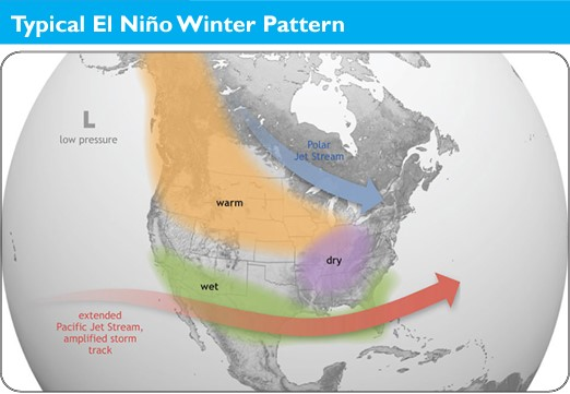
During El Niño winters, the polar jet stream tends to stay to the north of the Great Lakes region, while the Pacific jet stream remains across the southern U.S. With the Great Lakes positioned between the storm tracks, warmer and possibly drier conditions can develop during El Niño events.

What is lake effect snow?

In the Great Lakes region, hazardous winter weather often happens when cold air descends from the Arctic region. Lake effect snow is different from a low pressure snow storm in that it is a much more localized and sometimes very rapid and intense snow event. As a cold, dry air mass moves over the unfrozen and relatively warm waters of the Great Lakes, warmth and moisture from the lakes are transferred into the atmosphere. This moisture then gets dumped downwind as snow.
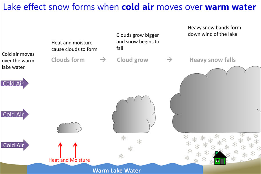
Graphic via NOAA National Weather Service

Lake Effect Snow Can Be Dangerous

Lake effect snow storms can be very dangerous. For example, 13 people were killed by a storm that took place November 17-19, 2014 in Buffalo, New York. During the storm, more than five  feet of snow fell over areas just east of Buffalo, with mere inches falling just a few miles away to the north. Not only were lives lost, but the storm disrupted travel and transportation, downed trees and damaged roofs, and caused widespread power outages. Improving lake effect snow forecasts is critical because of the many ways lake effect snow conditions affect commerce, recreation, and community safety. 

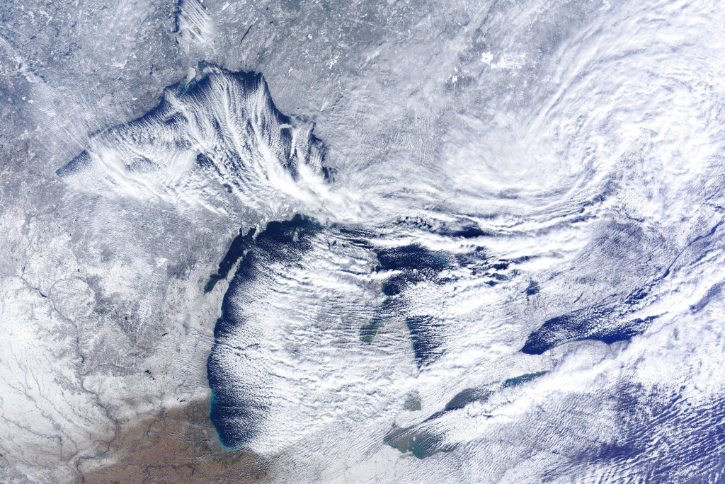
MODIS satellite image of a lake effect snow event in the Great Lakes, caused by extensive evaporation as cold air moves over the relatively warm lakes. November 20, 2014. Credit: NOAA Great Lakes CoastWatch.

Why is lake effect snow so hard to forecast?

There are a number of factors that make lake effect snow forecasting difficult. The widths of lake-effect snowfall bands are usually less than 3 miles — a very small width that makes them difficult to pinpoint in models. The types of field measurements scientists need to make forecasts better are also hard to come by, especially in the winter!  We would like to take frequent lake temperature and lake ice measurements, but that is difficult to do during the winter, as conditions are too rough and dangerous for most research vessels and buoys. (However, NOAA is making progress towards expanding our Great Lakes winter observation capabilities!)

Satellite measurements can also be hard to come by, as the Great Lakes region is notoriously cloudy in the winter. It’s not uncommon to go for over a week without usable imagery.

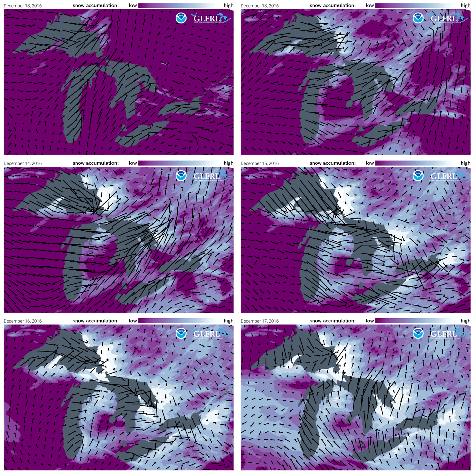
Lake Effect Snow animation: This mid-December 2016 lake effect snow event resulted in extremely heavy snow across Michigan, Ohio, upstate New York as well as the province of Ontario east of Lake Superior and Huron.

NOAA GLERL and CIGLR work to improve lake effect snow forecasting

Currently, NOAA Great Lakes operational models provide guidance for lake effect snow forecasts and scientists at NOAA GLERL and the Cooperative Institute for Great Lakes Research (CIGLR) are conducting studies to improve them. 

They use data from lake effect snow events in the past and compare how a new model performs relative to an existing model.  One way to improve forecast model predictions is through a model coupling approach, or linking two models so that they can communicate with each other. When they are linked, the models can share their outputs with each other and produce a better prediction in the end.

Research published by CIGLR, GLERL and other research partners, “Improvements to lake-effect snow forecasts using a one-way air-lake model coupling approach,” is part of a series of studies (see list below) that help to make lake effect snow forecasts better. This study takes a closer look at how rapid changes in Great Lakes temperatures and ice impact regional atmospheric conditions and lake-effect snow. Rapidly changing Great Lake surface conditions during lake effect snow events are not accounted for in existing operational weather forecast models. The scientists identified a new practical approach for how models communicate that does a better job of capturing rapidly cooling lake temperatures and ice formation. This research can result in improved forecasts of weather and lake conditions. The models connect and work together effectively and yet add very little computational cost. The advantage to this approach in an operational setting is that computational resources can be distributed across multiple systems.

Study model run: This panel of images shows model runs that looks at data from a lake effect snow event from January 2018 with and without the new type of model coupling. The image on the far right labeled Dynamic – Control Jan 06 shows the differences in air temperature (red = warmer, blue = colder) and wind (black arrows) when the models are coupled. The areas in color show how the new model coupling changed the model output considerably and improved the forecast.

Our lake effect snow research continues

Our lake effect modeling research is ongoing, and NOAA GLERL, CIGLR, NOAA NWS Detroit, the NOAA Global Systems Laboratory continue to address the complex challenges and our studies build upon each other to improve modeling of lake-effect snow events. A future focus will be on running the models on a smaller grid scale and continuing to work to improve temperature estimates as both are key to forecasting accuracy. 


Related news articles and blog posts: 

Improving Lake Effect Snow Forecasts

Improving lake effect snow forecasts by making models talk to each other

Related research papers: 

Fujisaki-Manome et al. (2022) Forecasting lake-/sea-effect snowstorms, advancement, and challenges

Fujisaki-Manome et al. (2020) Improvements to lake-effect snow forecasts using a one-way air-lake model coupling approach. 

Anderson et al. (2019) Ice Forecasting in the Next-Generation Great Lakes Operational Forecast System (GLOFS)

Fujisaki-Manome et al. (2017) Turbulent Heat Fluxes during an Extreme Lake-Effect Snow Event

Xue et al. (2016) Improving the Simulation of Large Lakes in Regional Climate Modeling: Two-Way Lake-Atmosphere Coupling with a 3D Hydrodynamic Model of the Great Lakes


Leave a comment

Underwater robots significantly advance our ability to study Lake Erie’s harmful algal blooms

Newly published research from the NOAA Great Lakes Environmental Research Laboratory (GLERL), the Cooperative Institute for Great Lakes Research (CIGLR), and partners reveals that using underwater robots could significantly advance scientists’ ability to study the harmful algal blooms (HABs) that appear in the Great Lakes and oceans every summer. You may remember reading about NOAA’s collaborative fieldwork in 2019 that used these robots to detect toxins in Lake Erie’s harmful algal bloom. Three years later, the findings from this pioneering research come bearing good news!

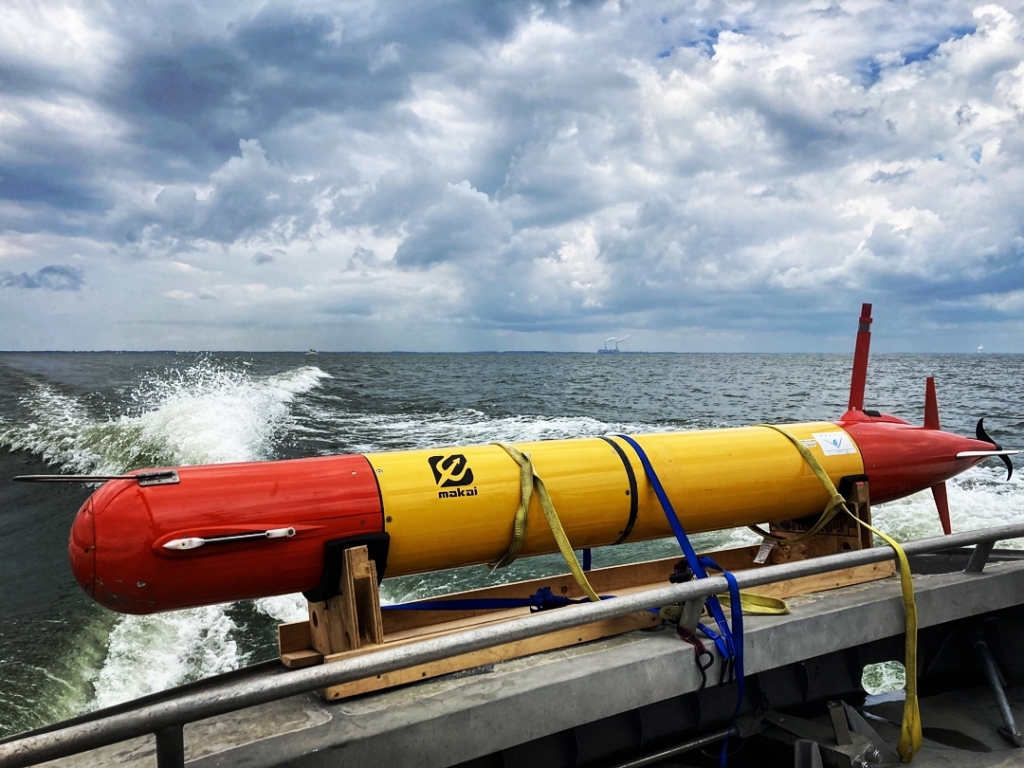
This autonomous underwater vehicle (AUV), known as “Makai,” visited the Great Lakes from the Monterey Bay Aquarium Research Institute (MBARI) to help scientists study Lake Erie’s harmful algal bloom. Credit: Steve Ruberg, NOAA GLERL

What are HABs, and how do we study them?

HABs occur when colonies of algae grow out of control and produce toxic or harmful effects on people, fish, shellfish, marine mammals and birds. Western Lake Erie in particular has been plagued by intensified HABs over the past decade. These blooms consist of cyanobacteria, or blue-green algae, which are capable of producing toxins that endanger human and animal health, compromise drinking water supplies, foul coastlines, and impact communities and businesses that depend on the lake. 

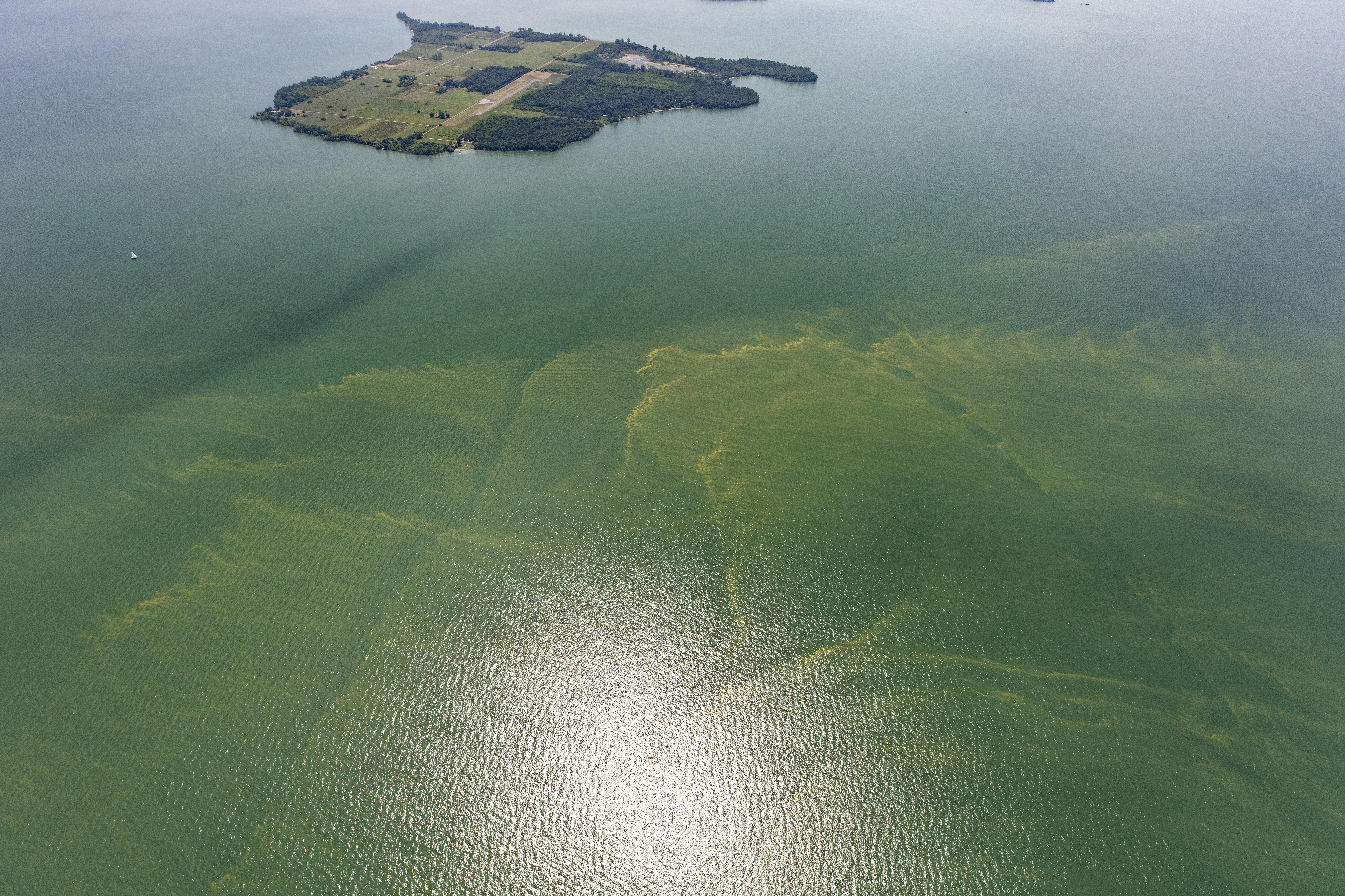
Harmful algal bloom in western Lake Erie in October, 2011. Credit: NOAA Great Lakes CoastWatch

The underwater robot used in this research project is known as a long-range autonomous underwater vehicle, or LRAUV. As the name suggests, the LRAUV is built to travel long distances beneath the water’s surface, collecting data for an extended period of time. LRAUVs are useful research tools, as they can collect high-quality data more efficiently and cost-effectively than scientists taking samples from a ship or along the shore. They can be deployed day and night in all weather conditions, and can provide more detailed information to researchers and drinking water managers than other monitoring methods.

For this project, NOAA and CIGLR teamed up with the Monterey Bay Aquarium Research Institute and university partners to equip an LRAUV with a 3rd Generation (3G) Environmental Sample Processor (ESP) — a mobile version of what has previously been known as NOAA’s “lab in a can.” The 3G ESP’s job is to measure microcystin, a potent liver toxin produced by the cyanobacteria that cause harmful algal blooms in the Great Lakes. In just a few hours, the 3G ESP can collect and analyze water samples from the bloom with the same methods that scientists use to analyze samples back at the lab. It does this with the use of ‘omics, a collective suite of technologies used to analyze biological molecules such as DNA, RNA, proteins, or metabolites. These technologies can be used to identify the algal species that produce HABs, understand their behavior, and predict shifts in their population structure.

NOAA and partners deployed the LRAUV-3G ESP in Lake Erie to autonomously measure microcystin, a potent liver toxin produced by the cyanobacteria that cause harmful algal blooms in the Great Lakes. Photo credit: NOAA

Did this robot step up to the challenge?

Before widely adopting the use of the LRAUV-3G ESP to study Lake Erie HABs, scientists had to ensure that the data these instruments collect is accurate and reliable. A main goal of the new publication was to assess how dependable the LRAUV-3G ESP’s data is compared to data that was collected and analyzed by humans.

The authors used a variety of parameters to assess the vehicle’s performance of ‘omics tests on samples it collected from the HAB. They ultimately found that the LRAUV-3G ESP successfully performed flexible, autonomous sampling across a wide range of HAB conditions, and the results indicated equivalency between autonomous and manual methods. In fact, no significant differences were found between LRAUV-3G ESP and manual sample collection and handling methods in the 12 parameters tested. In other words, this robot passed the test!

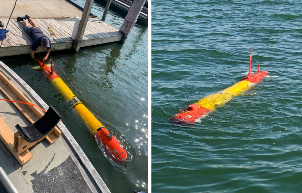
Left: Scientists retrieve the LRAUV-3G ESP from its mission to measure algal toxins in Lake Erie. Photo credit: NOAA AOML. Right: First author Paul Den Uyl (CIGLR) CIGLR retrieves 3G ESP filters for analysis of Lake Erie microbial community DNA. Photo Credit: Kelly Godwin.

One of the most exciting aspects of this research is that it shows that scientists can use an autonomous sampling platform to replicate traditional ship-based sampling, and they can do so in a particularly challenging environment (Lake Erie’s shallow western basin) where HABs are a serious health concern. Using this instrument in Lake Erie’s shallow waters presented another challenge for the scientists involved. In response to the lake’s challenges, researchers worked on the LRAUV’s buoyancy to ensure that the instrument didn’t drag across the ground. With this technology – sampling DNA and measuring toxins on an autonomous platform – NOAA and partners may be able to provide an early warning system for HABs in the future.

The 3rd Generation Environmental Sample Processor demonstrates engineering advancements from the first and second generation ESPs. Photo credit: NOAA GLERL.

Partners on this research came from far and wide to conduct this important research:

  • National Oceanic and Atmospheric Administration (NOAA)
    • NOAA Atlantic Oceanographic and Meteorological Laboratory (AOML), Ocean Chemistry and Ecosystems Division
    • NOAA Great Lakes Environmental Research Laboratory
    • NOAA National Centers for Coastal Ocean Science (NCCOS)
    • NOAA Southwest Fisheries Science Center
  • Cooperative Institute for Great Lakes Research (CIGLR), University of Michigan
  • Northern Gulf Institute, Mississippi State University
  • Monterey Bay Aquarium Research Institute (MBARI)
  • Department of Earth and Environmental Sciences, University of Michigan

Explore more photos of this research on NOAA GLERL’s Flickr page.


Leave a comment

Lake effect snow: What, why and how?

Winter is nearly here — and those who live and work in the Great Lakes region are already wondering what the winter of 2021 has in store. Early indications suggest a La Niña winter pattern, which shifts the odds towards cooler, wetter weather with more ice cover. 

More snow and ice can mean more fun, and can be great for winter sports like ice fishing, snowmobiling and skiing. Unfortunately, it can also mean severe weather events involving ice and snow. In the Great Lakes region, snow comes via the usual low pressure systems, but we also can get lake effect snow. 

Average location of the jet stream and typical temperature and precipitation impacts during La Niña winter over North America. Map by Fiona Martin for NOAA Climate.gov.

What is lake effect snow?

In the Great Lakes region, hazardous winter weather often happens when cold air descends from the Arctic region. Lake effect snow is different from a low pressure snow storm in that it is a much more localized and sometimes very rapid and intense snow event. As a cold, dry air mass moves over the unfrozen and relatively warm waters of the Great Lakes, warmth and moisture from the lakes are transferred into the atmosphere. This moisture then gets dumped downwind as snow.

Lake Effect Snow Can Be Dangerous

Lake effect snow storms can be very dangerous. For example, 13 people were killed by a storm that took place November 17-19, 2014 in Buffalo, New York. During the storm, more than five  feet of snow fell over areas just east of Buffalo, with mere inches falling just a few miles away to the north. Not only were lives lost, but the storm disrupted travel and transportation, downed trees and damaged roofs, and caused widespread power outages. Improving  lake effect snow forecasts is critical because of the many ways lake effect snow conditions affect commerce, recreation, and community safety.
Lake Effect Snow animation: Mid-December 2016 The lake effect snow EVENT resulted in extremely heavy snow across Michigan, Ohio, upstate New York as well as the province of Ontario east of Lake Superior and Huron.

Why is lake effect snow so hard to forecast?

There are a number of factors that make lake effect snow forecasting difficult. The widths of lake-effect snowfall bands are usually less than 3 miles — a very small width that makes them difficult to pinpoint in models. The types of field measurements scientists need to make forecasts better are also hard to come by, especially in the winter!  We would like to take frequent lake temperature and lake ice measurements but that is currently not possible to do during the winter, as conditions are too rough and dangerous for research vessels and buoys. Satellite measurements can also be hard to come by. The Great Lakes region is notoriously cloudy in the winter –  it’s not uncommon to go for over a week without usable imagery. 
MODIS satellite image of a lake effect snow event in the Great Lakes, caused by extensive evaporation as cold air moves over the relatively warm lakes. November 20, 2014. Credit: NOAA Great Lakes CoastWatch.

GLERL and CIGLR work to improve lake effect snow forecasting

Currently, NOAA Great Lakes operational models provide guidance for lake effect snow forecasts and scientists at NOAA GLERL and CIGLR are conducting studies to improve them. 

They use data from lake effect snow events in the past and compare how a new model performs relative to an existing model.  One way to improve forecast model predictions is through a model coupling approach, or linking two models so that they can communicate with each other. When they are linked, the models can share their outputs with each other and produce a better prediction in the end. 

Our lake effect snow research continues

Our lake effect modeling research is ongoing, and GLERL, CIGLR, NWS Detroit, the NOAA Global Systems Laboratory continue to address the complex challenges and and our studies build upon each other to improve modeling of lake-effect snow events. A new focus will be on running the models on a smaller grid scale and continuing to work to improve temperature estimates as both are key to forecasting accuracy.

A recent study, published by CIGLR and GLERL and other research partners, Improvements to lake-effect snow forecasts using a one-way air-lake model coupling approach,” is the latest in a recent series of studies* (see list below) that help to make lake effect snow forecasts better. This study takes a closer look at how rapid changes in Great Lakes temperatures and ice impact regional atmospheric conditions and lake-effect snow. Rapidly changing Great Lake surface conditions during lake effect snow events are not accounted for in existing operational weather forecast models. The scientists identified a new practical approach for how models communicate that does a better job of capturing rapidly cooling lake temperatures and ice formation. This research can result in improved forecasts of weather and lake conditions. The models connect and work together effectively and yet add very little computational cost. The advantage to this approach in an operational setting is that computational resources can be distributed across multiple systems.

Study model run: This panel of images shows model runs that looks at data from a lake effect snow event from January 2018 with and without the new type of model coupling. The image on the far right labeled Dynamic – Control Jan 06 shows the differences in air temperature (red = warmer, blue = colder) and wind (black arrows) when the models are coupled. The areas in color show how the new model coupling changed the model output considerably and improved the forecast.

Related news articles and blog posts:

From the CIGLR Winter 2020 eNewsletter – Improving Lake Effect Snow Forecasts

NOAA Research News, April 2019 NOAA research yields better lake-effect snow forecasts

NOAA GLERL Blog, 2018 – Improving lake effect snow forecasts by making models talk to each other

Related research papers: 

Fujisaki-Manome et al. (2020) Improvements to lake-effect snow forecasts using a one-way air-lake model coupling approach. 

Anderson et al. (2019) Ice Forecasting in the Next-Generation Great LakesOperational Forecast System (GLOFS) 

Fujisaki-Manome et al. (2017) Turbulent Heat Fluxes during an Extreme Lake-Effect Snow Event

Xue et al. (2016) Improving the Simulation of Large Lakes in Regional Climate Modeling: Two-Way Lake–Atmosphere Coupling with a 3D Hydrodynamic Model of the Great Lakes


Leave a comment

GLANSIS Technical Memos Add New Data to Invasive Species Risk Assessments

With over 180 non-native aquatic species currently present in the Great Lakes and potential new invaders on the horizon, keeping track of the impacts and risks that these organisms pose is an ongoing challenge. The Great Lakes Aquatic Nonindigenous Species Information System (GLANSIS), a one-stop shop for information about aquatic nonindigenous species,  hosts data on the historical and ongoing effects of aquatic organisms introduced to the region. Two NOAA Technical Memos serve as the underlying risk and impact assessments for the GLANSIS database and researchers recently completed important annual updates to these documents (TM-161c and TM-169c). These updates allow researchers to stay current on potential risk and impacts of these organisms to the ecosystem.

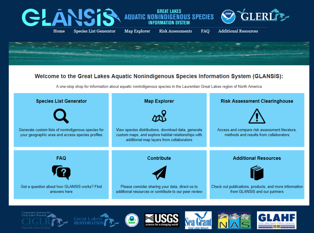
A screenshot of the GLANSIS homepage.
GLANSIS technical memos contain the risk and impact information provided by the database.

What are the GLANSIS tech memos?

NOAA Technical Memos are used for the timely documentation and communication of raw data, preliminary results of scientific studies, or interim reports that may not have received formal external peer reviews in the style of academic journal articles or manuscripts. These numbered publications are publically available online in PDF format, and serve as important research documentation and reference material.

The GLANSIS team updates two different tech memos every year by reviewing and synthesizing the scientific literature on invasive — or potentially invasive — aquatic species. The first, TM GLERL-161et seq., “An Impact Assessment of Great Lakes Aquatic Nonindigenous Species”, provides the updated impact assessments for nonindigenous species documented as reproducing and overwintering in the Great Lakes, focusing on their ecological, socio-economic, and beneficial impacts to the region. The second, TM GLERL-169 et seq., “A Risk Assessment of Potential Great Lakes Aquatic Invaders documents species that have been identified as likely to become invasive if introduced to the Great Lakes region. The 2019 updates document the updated impact assessments for 89 of the 188 nonindigenous species (TM-161c) and four assessments were updated and eight new species were added for potential invasives (TM-169c).  

Why are the tech memos updated every year, and why are they important?

The GLANSIS technical memos provide transparent, publicly-available documentation of the risk assessment process that underlies the species profiles in the database. Not only do they provide the summary information available in the website, they also share all the original sources and the details of the specific semi-quantitative analysis behind declaring particular species ‘high-impact’. New and improved data on aquatic invasive species is being published all the time, and documenting annual updates to risk and impact assessments helps to keep the GLANSIS database up-to-date and allows researchers to track the changes in the state of knowledge for specific species through the years. Each update takes a new look at how the latest data influences larger-scale patterns and trends. Unlike a website, where old versions are overwritten by the new, the technical memos provide a stable, citable reference point.

The GLANSIS tech memos can be read in full at the NOAA Great Lakes Environmental Research Lab’s publications page. To learn more about GLANSIS, check out https://www.glerl.noaa.gov/glansis/ and explore the site for yourself.


Leave a comment

The HAB season is over, but the work goes on

It’s nearly winter here in the Great Lakes—our buoys are in the warehouse, our boats are making their way onto dry land, and folks in the lab are working hard to assess observed data, experiments, and other results from this field season.

habtracker2018

This is a retrospective animation showing the predicted surface chlorophyll concentrations estimated by the Experimental Lake Erie HAB Tracker model during the 2018 season. Surface chlorophyll concentrations are an indicator of the likely presence of HABs. For more information about how the HAB Tracker forecast model is produced and can be interpreted, visit our About the HAB Tracker webpage.

The harmful algal bloom (HAB) season is also long over in the region. The final Lake Erie HAB Bulletin was sent out on Oct. 11, as the Microcystis had declined in satellite imagery and toxins decreased to low detection limits in samples. In the seasonal assessment, sent out by NOAA’s Centers for Coastal Ocean Science on Oct. 26, it was determined that the season saw a relatively mild bloom—despite its early arrival in the lake—and the bloom’s severity was significantly less than that which was predicted earlier in the season. These bulletins and outlooks are compiled using several models. Over the winter, the teams working on the models take what they learn from the previous season, and update their models for future use.

Back in the lab, the HABs team—researchers from both GLERL and the Cooperative Institute for Great Lakes Research (CIGLR)—will spend the winter analyzing data they collected through a variety of observing systems. This summer was packed with the use of new observing technologies, like hyperspectral cameras and the Environmental Sample Processor (in case you missed it, check out this fun photo story of the experimental deployment of a 3rd generation ESP). In addition, GLERL and CIGLR staff maintained a weekly sampling program program, from which scientists are analyzing and archiving samples and conducting experiments.

43447135081_b893240224_o.jpg

Aerial photograph of the harmful algal bloom in Western Basin of Lake Erie on July 2, 2018, (Photo Credit: Aerial Associates Photography, Inc. by Zachary Haslick). Pilots from Aerodata have been flying over Lake Erie this summer to map out the general scope of the algal blooms. In addition to these amazing photos, during the flyovers, additional images are taken by a hyperspectral imager (mounted on the back of the aircraft) to improve our understanding of how to map and detect HABs. The lead researcher for this project is Dr. Andrea VanderWoude, a NOAA contractor and remote sensing specialist with Cherokee Nation Businesses. For more images, check out our album on Flickr.

This lab work is super important for understanding the drivers of toxic algae in the Great Lakes. For instance, in a new study released this month, researchers looking at samples from previous years found that “ . . . the initial buildup of blooms can happen at a much higher rate and over a larger spatial extent than would otherwise be possible, due to the broad presence of viable cells in sediments throughout the lake,” according to the lead author Christine Kitchens, a research technician at CIGLR, who works here in the GLERL lab. This type of new information can be incorporated into the models used to make the annual bloom forecasts.

As you can see, our work doesn’t end when the field season is over.  In spring 2019, when the boats and buoys are back in the water and samples are being drawn from the lakes, researchers will already have a jump on their work, having spent the winter months analyzing previous years, preparing, and applying what they’ve learned to the latest version of the Experimental HAB Tracker, advanced observing technologies, and cutting-edge research on harmful algal blooms in the Great Lakes.


Leave a comment

NOAA GLERL collaborating with partners to monitor the Lake Huron ecosystem

This slideshow requires JavaScript.

The NOAA Great Lakes Environmental Research Laboratory (GLERL) is participating in an international, multi-agency effort to study invasive species, water quality, fisheries, and climate change in Lake Huron this field season—pursuing key knowledge gaps in the ecosystem. The Coordinated Science and Monitoring Initiative (CSMI) coordinates across U.S. and Canadian agencies to conduct intensive sampling in one Great Lake per year, on a five-year cycle. The Great Lakes Restoration Initiative, which is administered by the U.S Environmental Protection Agency (EPA), is funding this research.

“While GLERL has had a long-term research program focused on Lake Michigan, we are using this initiative to advance long-term research on Lake Huron,” said GLERL Director Deborah Lee. “Invasive species, warming temperatures, and changes in nutrient loading are putting as much stress on Lake Huron as on Lake Michigan. We want to better understand the Lake Huron ecosystem and develop modeling tools to predict how the lake is changing.”

Henry Vanderploeg, Ph.D., chief of GLERL’s Ecosystem Dynamics research branch and lead researcher for GLERL’s efforts in the pelagic (open water) portion of the initiative comments, “GLERL plays a critical role in the CSMI, addressing key science questions. GLERL’s high frequency temporal and spatial sampling will help determine nutrient and energy flows from tributaries, nearshore to offshore. This type of data is critical to effectively manage Lake Huron for water quality and fish production.” Frequent spatial surveys are key to understanding food web connections throughout the seasons.

Researchers from GLERL  will expand upon their recent work in Lake Michigan (CSMI 2015) and past work in Huron (2012) to determine fine-scale food-web structure and function from phytoplankton to fishes along a nutrient-rich transect (from inner Saginaw Bay out to the 65-m deep Bay City Basin) and along a nutrient-poor transect (from inner Thunder Bay out to the Thunder Bay basin) during May, July, and September. GLERL will collect additional samples of fish larvae and zooplankton along both transects in June to help estimate larvae growth, diet, density, and mortality and to identify fish recruitment bottlenecks.

“GLERL was instrumental in establishing the long-term monitoring efforts that provide the foundation for current CSMI food-web studies,” said Ashley Elgin, Ph.D., research ecologist in the Ecosystem Dynamics research branch. Elgin serves as the NOAA representative on the CSMI Task Team, part of the Great Lakes Water Quality Act Annex 10, alongside partners from the U.S. Geological Survey (USGS), EPA, the U.S. Fish & Wildlife Service, Environment and Climate Change Canada, and the Ontario Ministries of Natural Resources and the Environment and Climate Change. This year, Elgin is conducting critical mussel growth field experiments in Lake Huron, expanding upon work she developed in Lake Michigan.  She will be addressing the following questions: (1) How does quagga mussel growth differ between regions with different nutrient inputs?; and (2) How do growth rates compare between Lakes Michigan and Huron? Elgin will also coordinate a whole-lake benthic survey, which will update the status of dreissenid mussels and other benthic-dwelling organisms in Lake Huron.  

GLERL’s key research partner, the Cooperative Institute for Great Lakes Research (CIGLR), will deploy a Slocum glider for a total of sixteen weeks to collect autonomous measurements of temperature, chlorophyll, colored dissolved organic matter (CDOM), and photosynthetically active radiation (PAR) between outer Saginaw Bay and open waters of the main basin.  Deployment times and coverage will be coordinated with other glider deployments by the EPA Office of Research and Development (ORD) and/or USGS Great Lakes Science Center, spatial research cruises, and periods of expected higher nutrient loads (i.e., following runoff events).  

CSMI research cruises began in late April and will continue through September. Researchers are using an impressive fleet of research vessels, including EPA’s 180-foot R/V Lake Guardian, GLERL’s 80-foot R/V Laurentian and 50-foot R/V Storm, and two large USGS research vessels, the R/V Articus and R/V Sterling. Sampling missions will also be conducted aboard Environment Canada’s Limnos across Lake Huron. The Laurentian is fitted out with a variety of advanced sensors and sampling gear, making it especially suitable for examining fine-scale spatial structure.

Scientists from the USGS Great Lakes Science Center, the Michigan Department of Natural Resources, and the University of Michigan are also participating in the Lake Huron CSMI.


Leave a comment

Working to improve Great Lakes modeling

Print

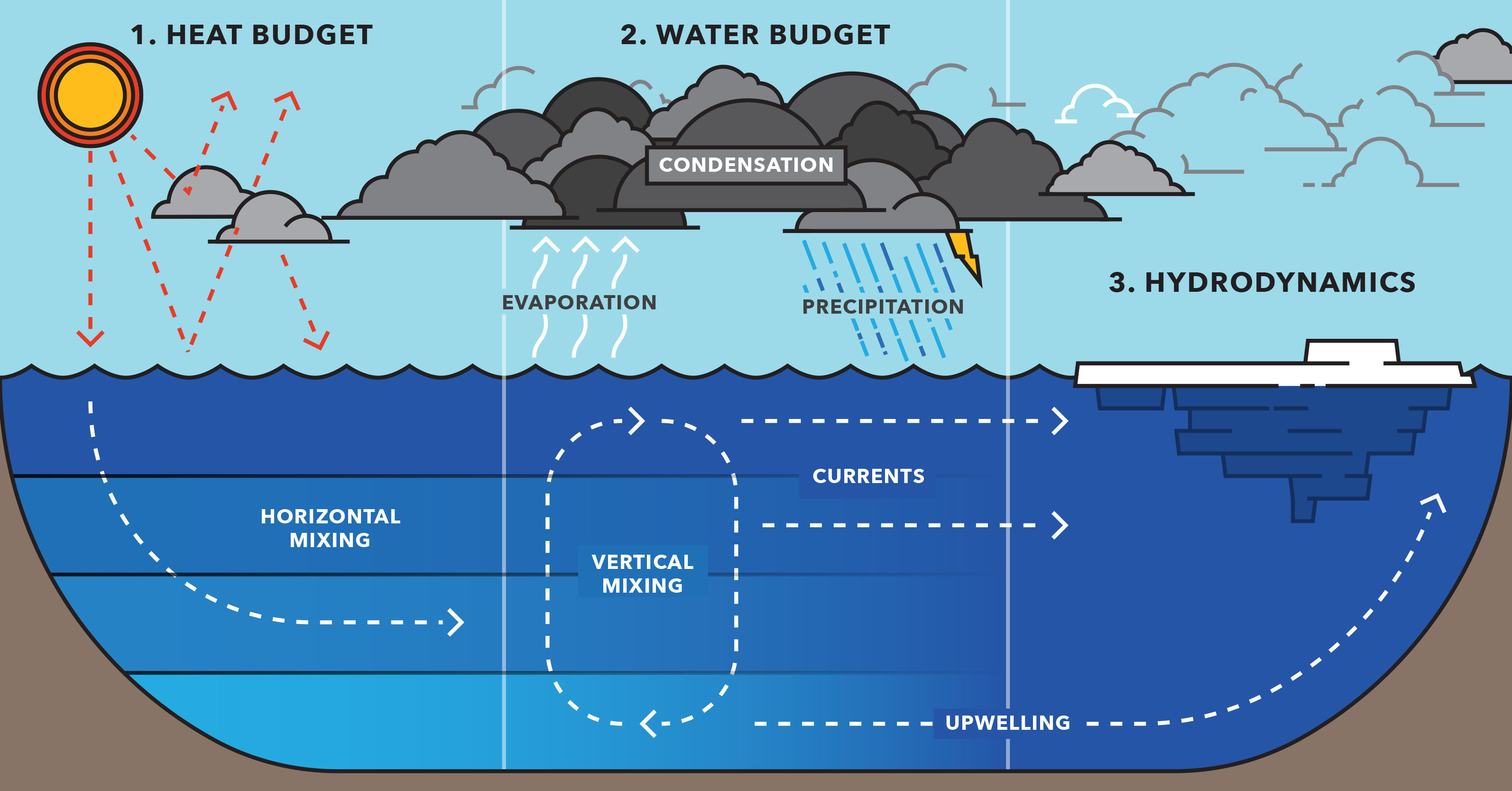
The new two-way coupled model is driven by heat budget estimates (how much energy enters the system); that affects the water budget and how much energy is exchanged between a lake and the atmosphere along with large lake processes that are dynamic and seasonally variable.

The Great Lakes are more like inland seas. From the cold depths of Lake Superior fisheries to the shallow algae blooms of Lake Erie, the bodies of water differ greatly from one another. Yet they are all part of one climate system.

Up until now, atmospheric models and hydrodynamic models have remained separate to a large extent in the region, with only a few attempts to loosely couple them. In a new study, published this week in the Journal of Climate, an integrated model brings together climate and water models.

The collaborative work brought together researchers from Michigan Technological University, Loyola Marymount University, LimnoTech as well as GLERL scientist, Philip Chu. Pengfei Xue, an assistant professor of civil and environmental engineering at Michigan Tech, led the study through his work at the Great Lakes Research Center on campus.

“One of the important concepts in climate change, in addition to knowing the warming trend, is understanding that extreme events become more severe,” Xue says. “That is both a challenge and an important focus in regional climate modeling.”

To help understand climate change and other environmental issues, Xue and his team connected the dots between the air and water of the Great Lakes. The new model will be useful for climate predictions, habitat modeling for invasive species, oil spill mitigation and other environmental research.

To read more about this research, please visit a full version of this Michigan Tech news article, posted by Allison Mills at: http://www.mtu.edu/news/stories/2016/november/weather-storm-improving-great-lakes-modeling.html