

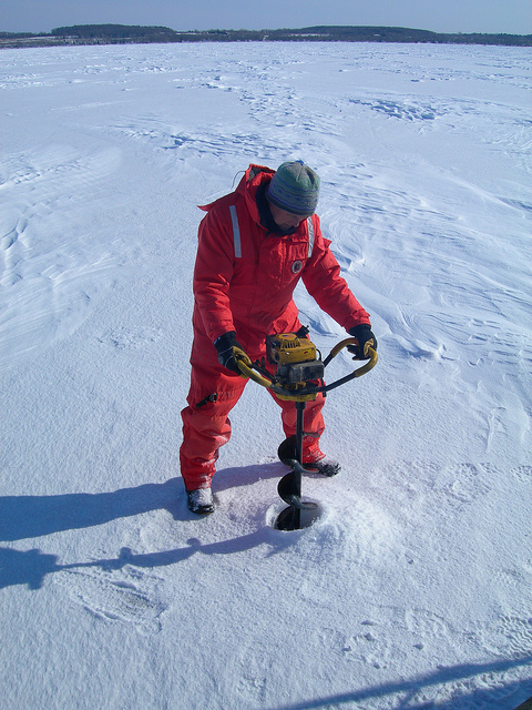
GLERL researcher, George Leshkevich, drilling through the ice in Green Bay, Lake Michigan.
NOAA’s Great Lakes Environmental Research Laboratory (GLERL) is on the cutting edge of using satellite remote sensing to monitor different types of ice as well as the ice cover extent. To make this possible, an algorithm—a mathematical calculation developed at GLERL to retrieve major Great Lakes ice types from satellite synthetic aperture radar (SAR) data—has been transferred to NOAA’s National Environmental Satellite, Data, and Information Service (NESDIS) for evaluation for operational implementation.
Once operational, the algorithm for Great Lakes ice cover mapping holds multiple applications that will advance marine resource management, lake fisheries and ecosystem studies, Great Lakes climatology, and ice cover information distribution (winter navigation). Anticipated users of the ice mapping results include the U.S. Coast Guard (USCG), U.S. National Ice Center (NIC), and the National Weather Service (NWS).
For satellite retrieval of key parameters (translation of satellite imagery into information on ice types and extent), it is necessary to develop algorithms specific to the Great Lakes owing to several factors:
- Ocean algorithms often do not work well in time or space on the Great Lakes
- Ocean algorithms often are not tuned to the parameters needed by Great Lakes stakeholders (e.g. ice types)
- Vast difference exists in resolution and spatial coverage needs
- Physical properties of freshwater differ from those of saltwater
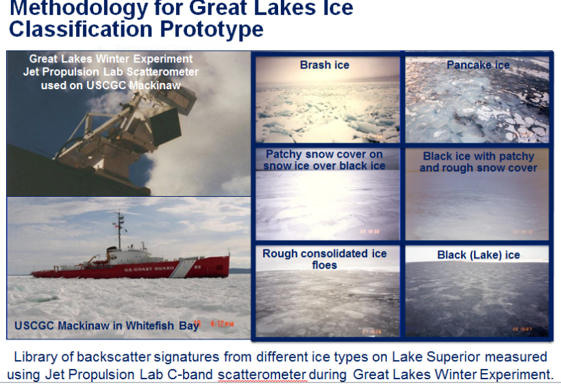
The relatively high spatial and temporal resolution (level of detail) of SAR measurements, with its all-weather, day/night sensing capabilities, make it well-suited to map and monitor Great Lakes ice cover for operational activities. Using GLERL and Jet Propulsion Lab’s (JPL) measured library of calibrated polarimetric C-band SAR ice backscatter signatures, an algorithm was developed to classify and map major Great Lakes ice types using satellite C-band SAR data (see graphic below, Methodology for Great Lakes Ice Classification prototype).
ICECON (ice condition index) for the Great Lakes—a risk assessment tool recently developed for the Coast Guard—incorporates several physical factors including temperature, wind speed and direction, currents, ice type, ice thickness, and snow to determine 6 categories of ice severity for icebreaking operations and ship transit. To support the ICECON ice severity index, the SAR ice type classification algorithm was modified to output ice types or groups of ice types, such as brash ice and pancake ice to adhere to and visualize the U.S. Coast Guards 6 ICECON categories. Ranges of ice thickness were assigned to each ice type category based on published freshwater ice nomenclature and extensive field data collection. GLERL plans to perform a demonstration/evaluation of the ICECON tool for the Coast Guard this winter.
Mapping and monitoring Great Lakes ice cover advances NOAA’s goals for a Weather-Ready Nation and Resilient Coastal Communities and Economies, and Safe Navigation. Results from this project, conducted in collaboration with Son V. Nghiem (NASA/Jet Propulsion Laboratory), will be made available to the user community via the NOAA Great Lakes CoastWatch website (https://coastwatch.glerl.noaa.gov).
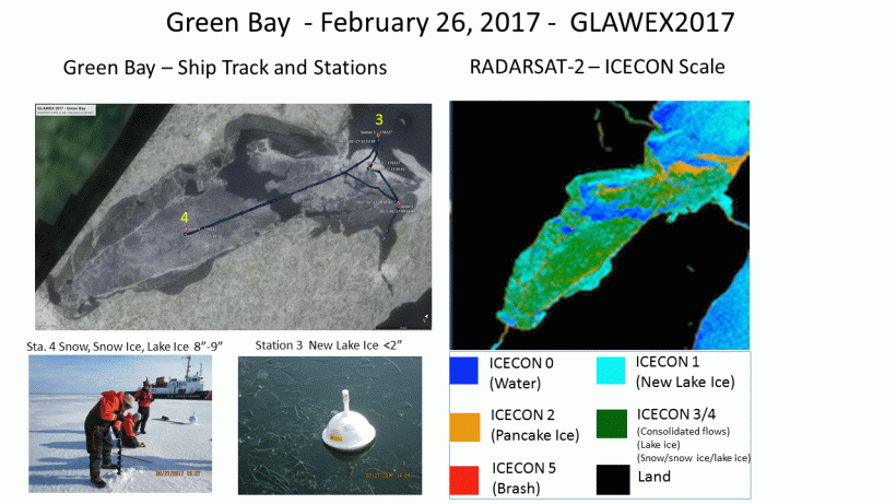
Measuring different ice types on Green Bay used to validate the ICECON (ice type classification) Scale in a RADARSAT-2 synthetic aperture radar (SAR) scene taken on February 26, 2017.
