NOAA Great Lakes Environmental Research Laboratory

The latest news and information about NOAA research in and around the Great Lakes


2 Comments

New science with historic data: 15 years of Great Lakes environmental data archived in NOAA data repository

With a network of experimental buoys that are constantly recording new data every few minutes, the amount of data the NOAA Great Lakes Environmental Research Laboratory (GLERL) has collected in the past 15 years is massive – and prepping it all to be archived in an official data repository is no small task. This year, thanks to the hard work of GLERL’s data managers and engineers, the Great Lakes environmental data collected by NOAA GLERL’s real-time buoys has been archived with NOAA’s National Centers for Environmental Information (NCEI) data repository. NCEI hosts and provides public access to one of the most significant archives of oceanic, atmospheric and geophysical data in the world.

A NOAA GLERL Real-Time Coastal Observation Network (ReCON) buoy in Lake Michigan.

An ever-growing collection of Great Lakes data

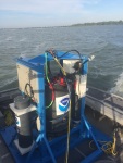
This real-time Great Lakes observational data archived in NCEI has been collected over time by sensors on coastal buoys as part of GLERL’s Real-Time Coastal Observation Network (ReCON). Each of ReCON’s 16 buoy stations collects meteorological data and provides sub-surface measurements of chemical, biological, and physical parameters (things like wave height, dissolved oxygen, chlorophyll, and water temperature). Totaling an impressive 2,055 data files, this data spans 15 years – from the inception of the first ReCON station in 2004 through the end of the 2019 field season. The data collected by GLERL’s ReCON buoys in the past 15 years are unique and valuable, and now that they are properly processed and easily accessible in the NCEI archive, they can be used in a variety of ways.

Using historic data to improve scientific models

While the near real-time info that our experimental ReCON buoys provide is great for helping you decide whether to hit the water for a day of boating or fishing, their usefulness doesn’t stop there. This Great Lakes ReCON data – both old and new – is incredibly useful to state and federal resource managers, educators, and researchers. For example, scientists can use the historic datasets to test the accuracy of their models, a process known as ‘hindcasting.’ When using archived data for hindcasting, researchers enter data for past events into their model to see how well the model’s output matches the known results. One cool example of hindcasting is the animation below that shows the Lake Superior wind and wave conditions that led to the sinking of the Edmund Fitzgerald in 1975.

Animation created with hindcasting that shows significant wave height and wind field, final voyage of the Edmund Fitzgerald, Nov 9-11, 1975.

As for the fact that ReCON data is collected in near real-time, these convenient same-day measurements can help determine whether or not a hypoxic (low oxygen) event will occur, detect nutrients contributing to harmful algal blooms, and even provide crucial data to the NOAA National Weather Service for coastal forecasting.

Water intake crib off the coast of Lake Erie in Cleveland, Ohio. Real-time data collected by NOAA GLERL’s ReCON buoys can help warn water intake managers of potential hypoxic events, which can affect drinking water quality.

Putting our data to the test

NOAA GLERL data manager Lacey Mason and marine engineer Ron Muzzi are in charge of preparing and submitting the data to NOAA’s NCEI data repository. Preparing the data to be archived involves performing quality assurance checks to ensure that it meets the Integrated Ocean Observing System’s (IOOS) standards set specifically for real-time oceanographic data. All of the data undergoes multiple quality tests before being archived, and each data point is flagged to indicate its reliability – whether it passed all tests, is suspect, or failed one or more tests.

In addition to being available on NOAA GLERL’s website and now the NOAA NCEI data repository, GLERL’s real-time buoy data can also be found on NOAA’s National Data Buoy Center website. The NCEI archive is fully updated with all of GLERL’s real-time data through 2019, and GLERL will continue to add new data to the archive on a yearly basis. The archived data can be accessed from the link here: https://doi.org/10.25921/jvks-b587.

photo of building in water with skyline of city in backgroun


Leave a comment

NOAA and partners team up to prevent future Great Lakes drinking water crisis

A new video SMART BUOYS: Preventing a Great Lakes Drinking Water Crisis released by Ocean Conservancy describes how NOAA forecast models provide advance warnings to Lake Erie drinking water plant managers to avoid shutdowns due to poor water quality.

An inter-agency team of public and private sector partners, working with the Cleveland Water Department, are addressing drinking water safety for oxygen depleted waters (hypoxia). By leveraging NOAA’s operational National Weather Service and National Ocean Service forecast models and remote sensing for the Great Lakes, NOAA’s latest experimental forecast models developed by its Great Lakes Environmental Research Laboratory can predict when water affected by harmful algal blooms and hypoxia may be in the vicinity of drinking water intake pipes. Advance notice of these conditions allows water managers to change their treatment strategies to ensure the health and safety of drinking water.  

“Hypoxia occurs when a lot of organic material accumulates at the bottom of the lake and decomposes. As it decomposes, it sucks oxygen from the water, can discolor the water and allow for metals to concentrate,” explains Devin Gill, stakeholder engagement specialist for NOAA’s Cooperative Institute for Great Lakes Research, hosted at the University of Michigan.

Low dissolved oxygen on its own is not a problem for water treatment. However, low oxygen is often associated with a high level of manganese and iron in the bottom water that then leads to drinking water color, taste, and odor problems. In addition, the same processes that consume oxygen also lower pH and, if not corrected, could cause corrosion in the distribution system, potentially elevating lead and copper in treated water.

“Periodically, this water with depleted oxygen gets pushed up against the shoreline and the drinking water intakes pipes,” said Craig Stow, senior research scientist for NOAA’s Great Lakes Environmental Research Laboratory. “We have buoys stationed at various places and those guide our models to let us know when conditions are right for upwellings that would move this hypoxic water into the vicinity of the drinking water intakes.”

NOAA provides advanced warning of these events so that drinking water plant managers can effectively change their treatment strategies to address the water quality, which is a huge benefit in the water treatment industry.


For more information on NOAA GLERL’s harmful algal blooms and hypoxia research, visit www.glerl.noaa.gov/res/HABs_and_Hypoxia.


Leave a comment

Analyzing Algal Toxins in Near Real-Time

This morning, along side our partners at the University of Michigan’s Cooperative Institute for Limnology and Ecosystems Research (CILER), we deployed the very first Environmental Sample Processor (ESP) in a freshwater system.

An ESP is an autonomous robotic instrument that works as a ‘lab in a can’ in aquatic environments to collect water samples and analyze them for algal toxins. This allows for near real-time (only a couple of hours for remote analyzation as opposed to a day or more back at the lab) detection of harmful algal blooms (HABs) and their toxins. GLERL’s ESP—named the ESPniagara—will measure concentrations of Microcystin, the dominant algal toxin in the Great Lakes. It will also archive samples, allowing us to genetically detect Microcystis, the predominant HAB in the Great Lakes, back in the laboratory.

There are 17 ESPs throughout the world and the ESPniagara is the only one (so far) being used in freshwater. We’ve placed it near the Toledo drinking water intake in western Lake Erie to collect and analyze water and detect concentrations of toxins that may be a health risk to people swimming, boating or drinking Lake Erie water. We’ll post the data from the on our HABs and Hypoxia webpage  so that drinking water managers and other end users can make water quality/ public health decisions.

The goal of this research is to provide drinking water managers with data on algal toxicity before the water reaches municipal water intakes. ESPniagara will strengthen our ability to both detect and provide warning of potential human health impacts from toxins.

This research proves to be a great collaborative effort for GLERL, CILER, and our partners. The Monterey Bay Aquarium Research Institute (MBARI) first developed the ESP, which is now commercially manufactured by McLane Laboratories. GLERL purchased the ESPniagara with funding from EPA-Great Lakes Restoration Initiative. NOAA-National Centers for Coastal Ocean Science (NCCOS) developed the technology to detect Microcystins (an ELISA assay). NCCOS funding also supported previous work to demonstrate the viability of ESP technology to assist in monitoring and forecasting of HABs and their related toxins in the marine environment.

We plan to have the ESPniagara out in western Lake Erie for the next 30 days. Check back later this week and next for a few videos, photos, and some pretty cool data. For more information, check out our HABs and Hypoxia website and read up on the ESP.


Leave a comment

UPDATE: GLERL Releases Drifter Buoys into Lake Erie

Update 08/09/2016: The buoys have drifted ashore and are being collected! The map below shows their full journey.

drifters map 2.1-01.png

This map shows the journey of the drifters from July 5, 2016 to August 5, 2016. Created by Kaye LaFond for NOAA GLERL. Click image to enlarge.


Original post 07/13/2016:

Last week, GLERL scientists released two mobile buoys with GPS tracking capabilities, known as ‘Lagrangian drifters’, into Lake Erie. We are now watching the buoys move around the lake with interest, and not just because it’s fun. The drifters help us test the accuracy of our Lake Erie hydrodynamics model, known as the Lake Erie Operational Forecasting System (LEOFS).

drifters map 2 [Converted]-01.png

This map shows the progress of the drifters as of July 13, 2016 08:19:00. Created by Kaye LaFond for NOAA GLERL. Click image to enlarge.

LEOFS is driven by meteorological data from a network of buoys, airports, coastal land stations, and weather forecasts which provide air temperatures, dew points, winds, and cloud cover.  The mathematical model then predicts water levels, temperatures, and currents (see below).

ewndcur_latest

An example of outputs from the Lake Erie Operational Forecast System (LEOFS)


We use these modeled currents to predict the path that something like, say, an algae bloom would take around the lake. In fact, this is the basis of our HAB tracker tool.

The strength of LEOFS is in how well the modeled currents match reality.  While there are a number of stationary buoys in Lake Erie, none provide realtime current measurements.  The drifters allow us to see how close we are getting to predicting the actual path an object would take.

Researchers will compare the actual paths of the drifters to the paths predicted by our model. This is a process known pretty universally as ‘in-situ validation’ (in-situ means “in place”). Comparing our models to reality helps us to continually improve them.

For more information and forecasts, see our Great Lakes Coastal Forecasting homepage.

For an up-to-date kmz file of the drifters (that opens as an animation in Google Earth), click here.