NOAA Great Lakes Environmental Research Laboratory

The latest news and information about NOAA research in and around the Great Lakes


Leave a comment

Underwater robots significantly advance our ability to study Lake Erie’s harmful algal blooms

Newly published research from the NOAA Great Lakes Environmental Research Laboratory (GLERL), the Cooperative Institute for Great Lakes Research (CIGLR), and partners reveals that using underwater robots could significantly advance scientists’ ability to study the harmful algal blooms (HABs) that appear in the Great Lakes and oceans every summer. You may remember reading about NOAA’s collaborative fieldwork in 2019 that used these robots to detect toxins in Lake Erie’s harmful algal bloom. Three years later, the findings from this pioneering research come bearing good news!

This autonomous underwater vehicle (AUV), known as “Makai,” visited the Great Lakes from the Monterey Bay Aquarium Research Institute (MBARI) to help scientists study Lake Erie’s harmful algal bloom. Credit: Steve Ruberg, NOAA GLERL

What are HABs, and how do we study them?

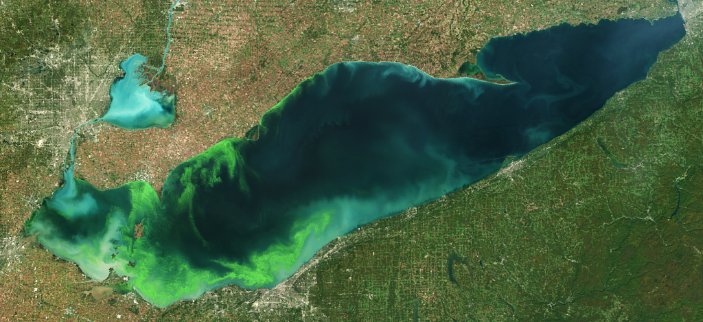
HABs occur when colonies of algae grow out of control and produce toxic or harmful effects on people, fish, shellfish, marine mammals and birds. Western Lake Erie in particular has been plagued by intensified HABs over the past decade. These blooms consist of cyanobacteria, or blue-green algae, which are capable of producing toxins that endanger human and animal health, compromise drinking water supplies, foul coastlines, and impact communities and businesses that depend on the lake. 

Harmful algal bloom in western Lake Erie in October, 2011. Credit: NOAA Great Lakes CoastWatch

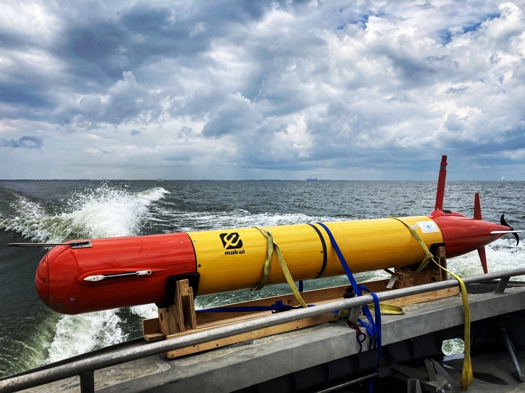
The underwater robot used in this research project is known as a long-range autonomous underwater vehicle, or LRAUV. As the name suggests, the LRAUV is built to travel long distances beneath the water’s surface, collecting data for an extended period of time. LRAUVs are useful research tools, as they can collect high-quality data more efficiently and cost-effectively than scientists taking samples from a ship or along the shore. They can be deployed day and night in all weather conditions, and can provide more detailed information to researchers and drinking water managers than other monitoring methods.

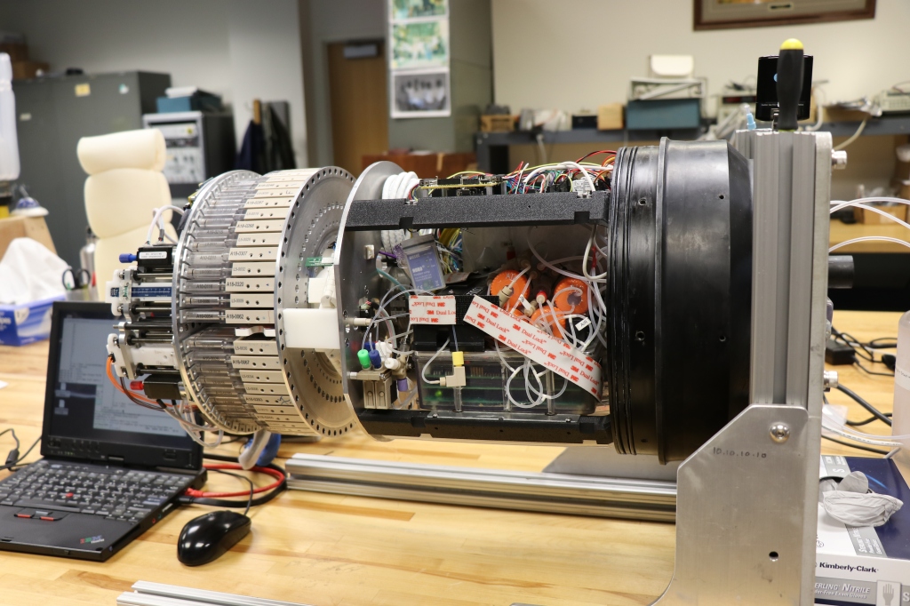
For this project, NOAA and CIGLR teamed up with the Monterey Bay Aquarium Research Institute and university partners to equip an LRAUV with a 3rd Generation (3G) Environmental Sample Processor (ESP) — a mobile version of what has previously been known as NOAA’s “lab in a can.” The 3G ESP’s job is to measure microcystin, a potent liver toxin produced by the cyanobacteria that cause harmful algal blooms in the Great Lakes. In just a few hours, the 3G ESP can collect and analyze water samples from the bloom with the same methods that scientists use to analyze samples back at the lab. It does this with the use of ‘omics, a collective suite of technologies used to analyze biological molecules such as DNA, RNA, proteins, or metabolites. These technologies can be used to identify the algal species that produce HABs, understand their behavior, and predict shifts in their population structure.

NOAA and partners deployed the LRAUV-3G ESP in Lake Erie to autonomously measure microcystin, a potent liver toxin produced by the cyanobacteria that cause harmful algal blooms in the Great Lakes. Photo credit: NOAA

Did this robot step up to the challenge?

Before widely adopting the use of the LRAUV-3G ESP to study Lake Erie HABs, scientists had to ensure that the data these instruments collect is accurate and reliable. A main goal of the new publication was to assess how dependable the LRAUV-3G ESP’s data is compared to data that was collected and analyzed by humans.

The authors used a variety of parameters to assess the vehicle’s performance of ‘omics tests on samples it collected from the HAB. They ultimately found that the LRAUV-3G ESP successfully performed flexible, autonomous sampling across a wide range of HAB conditions, and the results indicated equivalency between autonomous and manual methods. In fact, no significant differences were found between LRAUV-3G ESP and manual sample collection and handling methods in the 12 parameters tested. In other words, this robot passed the test!

Left: Scientists retrieve the LRAUV-3G ESP from its mission to measure algal toxins in Lake Erie. Photo credit: NOAA AOML. Right: First author Paul Den Uyl (CIGLR) CIGLR retrieves 3G ESP filters for analysis of Lake Erie microbial community DNA. Photo Credit: Kelly Godwin.

One of the most exciting aspects of this research is that it shows that scientists can use an autonomous sampling platform to replicate traditional ship-based sampling, and they can do so in a particularly challenging environment (Lake Erie’s shallow western basin) where HABs are a serious health concern. Using this instrument in Lake Erie’s shallow waters presented another challenge for the scientists involved. In response to the lake’s challenges, researchers worked on the LRAUV’s buoyancy to ensure that the instrument didn’t drag across the ground. With this technology – sampling DNA and measuring toxins on an autonomous platform – NOAA and partners may be able to provide an early warning system for HABs in the future.

The 3rd Generation Environmental Sample Processor demonstrates engineering advancements from the first and second generation ESPs. Photo credit: NOAA GLERL.

Partners on this research came from far and wide to conduct this important research:

  • National Oceanic and Atmospheric Administration (NOAA)
    • NOAA Atlantic Oceanographic and Meteorological Laboratory (AOML), Ocean Chemistry and Ecosystems Division
    • NOAA Great Lakes Environmental Research Laboratory
    • NOAA National Centers for Coastal Ocean Science (NCCOS)
    • NOAA Southwest Fisheries Science Center
  • Cooperative Institute for Great Lakes Research (CIGLR), University of Michigan
  • Northern Gulf Institute, Mississippi State University
  • Monterey Bay Aquarium Research Institute (MBARI)
  • Department of Earth and Environmental Sciences, University of Michigan

Explore more photos of this research on NOAA GLERL’s Flickr page.


Leave a comment

Decades in the making, NOAA’s newest Lake Superior and Lake Ontario forecast systems become fully operational

Did you know that NOAA operates a forecasting system that predicts water conditions on the Great Lakes? Whether you’re wondering about a lake’s temperature, currents, or water level changes, NOAA’s got you covered! This fall, NOAA implemented newly updated versions of the Lake Superior and Lake Ontario portions of this system, and added ice forecasts to all five lakes.

Lake Michigan waves at the St. Joseph North Pier Lighthouses following superstorm Sandy. October 29, 2012. Credit: S. Lashley, NOAA NWS.

GLOFS forecasts Great Lakes conditions

The publicly available Great Lakes Operational Forecast System (GLOFS) is a NOAA automated, model-based prediction system aimed at providing improved predictions of these conditions in the five Great Lakes (Erie, Michigan, Superior, Huron and Ontario) for the commercial, recreation, and emergency response communities. GLOFS models use current lake conditions and predicted weather patterns to forecast the lake conditions for up to five days (120 hours) in the future. GLOFS predictions enable users to increase the margin of safety and maximize the efficiency of commerce throughout the Great Lakes.

NOAA’s National Weather Service (NWS) and National Ocean Service (NOS) work together to run GLOFS operationally on NOAA’s High Performance Computing System. By running on NOAA’s High Performance Computing System, GLOFS has direct access to National Weather Service operational meteorological products that are required for reliable and timely operations.

A major update for Lakes Ontario and Superior

A key goal of NOAA’s Research branch is to continually make forecasts better, and GLERL scientists play a major role in improving the models that constitute GLOFS. Like the rest of GLOFS, the Lake Ontario and Lake Superior portions – Lake Ontario Operational Forecast System (LOOFS) and Lake Superior Operational Forecast System (LSOFS) – were originally based on the Princeton Ocean Model. As of October 2022, they’ve now been upgraded with higher-resolution versions that are based on a newer computer model.

MODIS satellite images of Lakes Superior (left) and Ontario (right) in March 2021.

The new LOOFS and LSOFS use the Finite Volume Community Ocean Model (FVCOM), coupled with an unstructured grid version of the Los Alamos Sea Ice model (CICE). The new model provides users with higher resolution of nowcast (near-present conditions) and forecast guidance of water levels, currents, water temperature, ice concentration, ice thickness and ice velocity out to 120 hours in the future, and it updates four times per day. By invoking advanced model schemes and algorithms, LOOFS and LSOFS are expected to generate a more accurate model output than their former versions. 

Before they were ready to become operational, the new versions of LOOFS and LSOFS were run experimentally at GLERL for several years, where they underwent extensive testing and evaluation. GLERL played a key role in developing these models and ran them as part of the Great Lakes Coastal Forecasting System (GLCFS) – an experimental version of GLOFS that GLERL uses to prepare new models to become operational.

With this transition, the GLOFS models for all five Great Lakes have now been upgraded to FVCOM versions, as the Lake Erie model was upgraded in 2016, and the Lake Michigan-Huron model was upgraded in 2019. A new FVCOM-based model for the Huron-Erie Corridor, which includes Lake St. Clair and both the St. Clair and Detroit Rivers, is scheduled to be added to GLOFS in 2023. Read more about the LOOFS and LSOFS transition here.

These output maps from the current 3rd generation GLOFS show Lake Superior wind speed
and direction (top) and Lake Ontario water temperatures (bottom).

GLERL has been improving GLOFS for over 30 years

GLOFS is based on the Great Lakes Forecasting System, originally developed by The Ohio State University (OSU) and GLERL in the late 1980s and 1990s under the direction of Dr. Keith Bedford (OSU) and Dr. David Schwab (NOAA GLERL). The original forecasting systems utilized the Princeton Ocean Model (POM) and used a set of uniformly structured bathymetric grids. The first routine nowcast, using a low-resolution grid for Lake Erie, began at OSU in 1992.

Starting in 2002, GLERL’s semi-operational GLCFS was expanded to five lakes using medium-resolution grids (5 – 10 km) and 48-hr forecasts were added. This version was successfully transferred from research to operations at NOAA NOS in 2010. The transition to operations at NOAA NOS was a joint effort between NOAA GLERL, NOS Center for Operational Oceanographic Products and Services (CO-OPS) and NOS Office of Coast Survey (OSC) Coast Survey Development Laboratory (CSDL), private industry, and academia (OSU).

NOAA GLERL has continued to make improvements to the experimental GLCFS; these include increasing the grid resolution (2 – 10 km), adding ice dampening and an ice model, and extending the forecasts to 120 hours during the period of 2006-2014 (generation 2). The current 3rd generation of the GLOFS is what you see run by NOS today, with a resolution of 200m to 2.5km and producing 120-hour forecasts.

The development and implementation of LSOFS and LOOFS is a joint project across several NOAA offices and external partners. 

  • NOAA National Ocean Service Center for Operational Oceanographic Products and Services
  • NOAA NOS Office of Coast Survey
  • NOAA Office of Oceanic and Atmospheric Research Great Lakes Environmental Research Laboratory
  • Finite Volume Community Ocean Model development group at the University of Massachusetts Dartmouth
  • NOAA National Weather Service National Centers for Environmental Prediction Central Operations